2nd International Conference, Indonesia, 2005 – Conference Report
2nd International Conference, Indonesia, 2005 – Conference Report
A joint IGCP 495 – INQUA Meeting
International Conference and Field Trip on:
Quaternary Ocean & Land Interaction: Climatic, Tectonic & Anthropogenic Influence
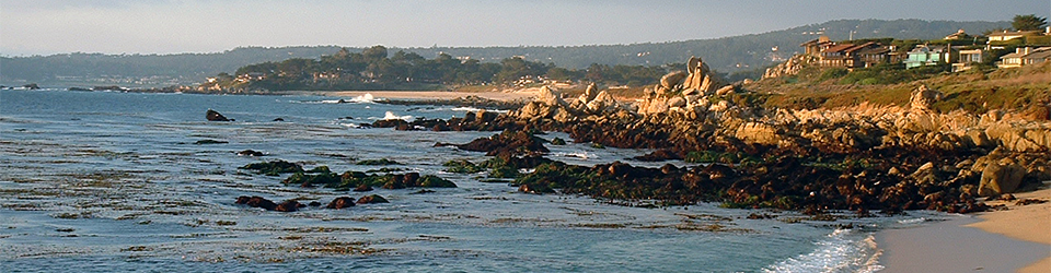
Anyer-Carita, Banten-Sunda Strait Area, Indonesia
24th – 30th September, 2005
Conference Report
This report describes the second international meeting of IGCP Project 495 which was hosted by Dr Wahyoe Hantoro and colleagues from the Research Centre for Geotechnology, Indonesian Institute of Sciences (LIPI). The conference was attended by 30 delegates from ten countries and comprised two days of scientific papers (30 in total), a poster session and a three day fieldtrip to the Sunda Strait region. The base for the meeting was Carita Cottages, located on the west coast of Java opposite Krakatau. This venue provided the ideal venue for the conference because much of the vast population of Indonesia (at the last count, in excess of 230 million), live close to or are in some way dependent on the coast for their livelihood. Moreover, as the events of the Indian Ocean tsunami demonstrated, the region regularly experiences large plate boundary earthquakes, tsunami, as well as numerous volcanic eruptions.
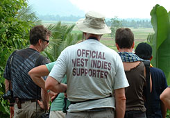
After arrival in the sprawling metropolis of Jakarta, delegates were transported by bus to Carita, a coastal town frequented (before the Indian Ocean tsunami, at least) by weekenders from Jakarta. The late afternoon provided an opportunity to refresh from jet-lag with a short boat trip to a nearby reef, damaged by overfishing as well as pollution but populated by at least one turtle that, thanks to the expert swimming of Hervé Regnault, temporarily became the 31st conference delegate. The evening ice breaker was attended by the President of LIPI, Professor Hery Harjono, who welcomed delegates to the Indonesia and then led the evening musical entertainment with a karaoke duet with Dr Wahyoe Hantoro. This was followed by successive humiliations to the non-Indoneisan vocalists, photographs and video footage of which will haunt many of us for years to come.
The first day of the scientific session began with welcomes and a keynote lecture from Dr Hantotoro who introduced delegates to the Sunda Strait region, paying particular attention to the Krakatau eruption of 1883 and the devastating effects of the accompanying tsunami and ash fall-out across the region. The rest of the session comprised papers on the main conference theme of Quaternary land-ocean interactions. UK delegates presentations included: Martyn Waller (University of Kingston) on dating the upper surface of late Holocene coastal peat layers in coastal lowlands, Antony Long (Durham University) on the response of the Greenland ice sheet margin to the 8.2 ka BP event, and Roland Gehrels (Plymouth University) on the possible influence of steric effects on the late Holocene relative sea-level history of west Iceland.
The first session of the second day of papers focused on coastal processes and human impacts, including shocking accounts of the pollution of Jakarta Bay by the 11 million residents of a city that lacks any sewerage waste processing facilities. The second session addressed the Indian Ocean tsunami and palaeotsunami research in general. This was the highlight of the two days of papers, with presentations providing up-dates on the impacts of the tsunami on Banda Aceh (Masatumo Umitsu, Nagoya University, Japan) and Hamzah Latief (LIPI, Indonesia), as well as the Maldives (Sue Dawson, St Andrews) and Thailand (Masatumo Umitsu). In addition to the well-known devastation caused by the tsunami, these papers cast important new light on the processes of tsunami wave impact and coastal responses, as well as the variable nature of post-event recovery. The session ended with a presentation by David Smith (Oxford University) on a new method for using grain size data to infer the maximum palaeo-tsunami run-up, reminding us of the importance of the palaeo record as an archive for understanding former tsunami occurrence and dynamics.
The scientific session ended with a field trip introduction and a business meeting. The main item for discussion in the latter was the programme of future IGCP495 meetings that will include a field meeting to examine the tsunami record of Bonair (March 2006), a joint IGCP/INQUA conference and field meeting to Romney Marsh and Dungeness (July 2006), the third International project meeting to be held in Santa Catarina State, Brazil (September 2006), and a proposal for the fourth international meeting to Bangladesh (November 2007).
The field trip focused on two themes: the impacts of the 1883 Krakatau eruption and tsunami; and the record of Holocene sea-level changes and neotectonics in Java and Sumatra. After 20 years of relative dormancy, the Krakatau complex became active in May 1883. Late in the morning of August 27th, the Krakatau caldera began to collapse, sending out successive tsunami that radiated out across the Indian Ocean. Initially, the tsunami that struck the Java coast were small – only 1 to 2m in height – but they were merely the warm-up act before a catastrophic tsunami struck the coast shortly after 11.30 am on August 28th, causing widespread destruction and killing over 80,000 Indonesians. Modelling and direct observations suggest that at places the tsunami run-up exceeded 40 m along the Anyer coast, taking some 30-40 minutes to travel outwards from the collapsed caldera (a distance of c.90 km).
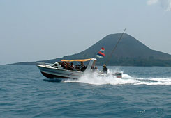
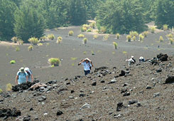
Day one of the field trip saw conference delegates gathered on the hotel beach shortly after dawn for embarkation on a small flotilla of boats that skimmed across the modest morning swell towards the Krakatau complex, scattering flying-fish. About an hour after departure the Krakatau complex emerged through the morning haze, gradually growing in size as we approached the southern wall of Rakatau, the former outer rim of the volcano. Ahead of us was Anak Krakatau or “son of Krakatau”, which first emerged above sea-level from the caldera floor in 1928 as a 3 m-high crater rim, some 175 m long. Since this time Anak Krakatau has risen to attain its current elevation of just under 300m asl.
Our flotilla landed on the scalding black sand beach of Anak Krakatau, from where we climbed through sweltering heat past geophysical monitoring equipment to reach the smoking summit crater. This was the highest point reached by a group of sea-level experts for some time, but recovering our energy on the summit and looking out across the vast caldera complex beneath us, it was impossible not to be moved by this stunning tsunami birthplace. Descending back to the boats we enjoyed a cooling swim, snorkeling on the beautiful colonising reef at the foot of the caldera wall that has developed since the 1883 eruption. As we were to see in the coming days, the ability of natural and human systems to recover from such a devastating event is remarkable, and a source of optimism when reflecting on the 2005 Indian Ocean tsunami.
By 3.00pm it was time to leave the Krakatau complex and head for Carita once more, jetting across an increasingly rough Sunda Strait. This region has a reputation for sudden storms, high seas and poorly maintained boats. All three appeared to combine towards the end of a trip that few of us will ever forget, as we smashed our way through growing swell, were soaked by waves and then torrential rain from a tropical thunderstorm, before each boat ran out of fuel almost within reach of the Carita coast. All was not lost though – new fuel supplies were found and ferried between boats and we finally made shore, sun-burnt, shaken but exhilarated from a remarkable day.
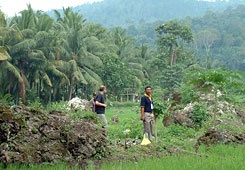
The second field day began at 6.00am with the coach rumbling north along the Anyer coast to Merek Harbour, from where crossed the Sunda Strait to Sumatra. The rest of a very long the day was spent weaving northwards through the rice fields along the coast road, examining the effects of the 1883 tsunami and numerous large blocks of Porites sp. coral reef, tossed tens or even hundreds of meters inland.
The final day of the meeting focused on the Holocene sea-level history of Java and further evidence for the 1883 tsunami along the west Banten coast. At our first stop, on Mantaram Beach, Dr Wahyoe Hantoro demonstrated a relict mid Holocene reef, c. 1.5m above present mean sea-level and, inland, a palaeo back-swamp area, now rice fields, that was once a mangrove swamp. The lack of pre-Holocene reef material here is attributed to tectonic subsidence that has affected this part of the coast, or to its burial beneath the younger Banten tuff that mantles much of the region in several meters of sediment.
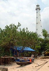
Our lunch was taken at the new Anyer lighthouse. The original brick-built structure, replaced in 1885 by the current steel construction, was destroyed by the 1883 tsunami that here reached over 40 m. We traced isolated blocks of the original structure embedded in the banks and floor of a neighbouring muddy creek. Further inland we cane across a very large block of the Holocene coral reef, standing like a memorial to the 1883 tsunami on a small clearing amongst wooden shacks. Once again it was striking to reflect on the resilience (and vulnerability) of these communities, now re-established amongst the debris of a tsunami just over 100 years old.
In the afternoon we continued to travel north, visiting the port and ruins of Surosurvan Palace, an important harbour of older West Java (Sunda) kingdom that was formerly connected to Jasinga Bogor, the capital of the Pajararan kingdom. Now isolated from the sea by siltation and artificial drainage, the site was a fitting finale for a meeting concerned with the dynamic interface between land and sea.
Surosuwan marked the end of the conference and delegates returned to Jakarta before dispersing. It remains to pay a heart-felt thanks to Dr Wahyoe Hantoro and the LIPI conference and fieldtrip committee for running a quite superb field meeting. The timing of the conference, just 9 months after the 2005 Indian Ocean tsunami, meant that for many delegates this was a particularly significant meeting. As a community that concerns itself with sea-level changes and their impacts coastal communities, the 2005 IGCP495 international conference was both sobering and yet enormously stimulating. We took with us from Indonesia vivid memories of the immense power of tectonic processes in controlling coastal evolution, as well as admiration and respect for the often poor and vulnerable people who live on these beautiful but unpredictable coastlines.
Further information on IGCP495 “Quaternary Land-Ocean Interactions: Driving Mechanisms and Coastal Responses” can be found from the UK National Correspondent, Dr Roland Gehrels (University of Plymouth, [email protected])
References
Hantoro, W. (ed) 2005. International Geological Correlation Programme #495 “Quaternary Ocean and Land Interaction: climatic, tectonic and anthropogenic influence. Programme and Abstracts, Research Center for Geotechnology – Indonesian Institute of Sciences (LIPI), 72 pages.
Hantoro, W. (ed) 2005. International Geological Correlation Programme #495 “Quaternary Ocean and Land Interaction: climatic, tectonic and anthropogenic influence. A Guide Book. Research Center for Geotechnology – Indonesian Institute of Sciences (LIPI), 80 pages.
Professor Antony Long
Department of Geography
Durham University
Science Site
South Road
Durham DH1 3LE
e-mail: [email protected]