3rd Meeting Eastern Fife and Tayside 2007 – Conference Report
3rd Meeting Eastern Fife and Tayside 2007 – Conference Report
A joint INQUA – IGCP 495 Meeting
International Conference and Field Trip on:
Holocene land-ocean interactions: Driving mechanisms and coastal responses
St Andrews
1st July – 4th July, 2007
A conference and field meeting to Eastern Fife and Tayside, organised jointly by the UK working group of IGCP Project 495 and the INQUA Commission on Coastal and Marine Processes.
Conference Report
Simon will be sorely missed by both friends and colleagues alike.
Photo courtesy of R. Gehrels.
The scenic coastal city of St Andrews in Scotland provided the setting for the third joint meeting of the UK working group of IGCP Project 495 and the NW Europe working group of the INQUA commission on coastal and marine processes. The conference organisers, Sue Dawson (University of St Andrews) and Alastair Dawson (University of Aberdeen and University of St Andrews) are congratulated for their tremendous efforts in bringing together over 20 colleagues from around the UK and NW Europe to St Andrews for a one-day scientific session followed by a two-day fieldtrip to visit coastal sites across eastern Fife and Tayside.
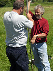
Colleagues were welcomed to the scientific paper session by Roland Gehrels (Plymouth) who dedicated the meeting to Simon Jennings (Figure 1), who died on October 3rd 2006. Simon, who was based at London’s Metropolitan University, devoted his working life to the study of shingle beaches and sea-level change. As an active member of the UK IGCP sea-level working group, Simon will be sorely missed by both friends and colleagues alike.
The scientific session opened with a series of papers that examined human coastal interactions. The first by Cecile Baeteman (Belgium Geological Survey) examined Roman peat-extraction pits as possible evidence for the timing of coastal changes along the Belgium coastal plain. The second, by David Dawson (Plymouth), examined the impact of future sea-level rise and increased storminess on the London-Penzance railway line – a topic which has wide ranging implications for government policy. The session continued with presentations from Helene Burningham (UCL) who detailed work on inlet-barrier behaviour in northwest Ireland, and Peter Vos (Geological Survey of the Netherlands) who presented evidence for the development of the Oer-IJ estuary in Holland.
The development of microfossil-based transfer functions for quantitatively reconstructing changes in relative sea level (RSL) has been a major theme at recent IGCP 495 meetings. In the second scientific session of the day, Sarah Woodroffe (Durham) illustrated the potential of this approach in the salt marshes of Greenland. Here, small pockets of salt marsh are being investigated in terms of their sedimentary, microfossil and isotopic characteristics for the first time. Staying with a northern theme, Alastair Dawson then presented chemistry data from the GISP2 ice core and combined this with historical records of past climate to highlight a major change in North Atlantic circulation around 1420 AD. Moving on, David Smith (Oxford) outlined the analysis of high quality altitude data using Gaussian Quadratic Trend Surface Analysis. Using this technique, patterns of glacio-isostatic uplift for displaced shorelines around the UK and Ireland were determined and are argued to be the most accurate yet produced for a glacio-isostatically uplifting area. In the last presentation of the session, Jasper Knight (Exeter) demonstrated the links between (raised) shoreline features and sea level from a sedimentological viewpoint, using examples from the Cornish and southern Irish coastlines.
The final scientific session of the day focussed on the theme of methodologies for reconstructing and dating. The session began with a keynote address by Michael Tooley (St Andrews and Kingston) who provided a review of the development of the Troels-Smith scheme of stratigraphic classification. Michael’s presentation stimulated a lively debate on the advantages and disadvantages of using the Troels-Smith scheme in the context of modern computing and graphical developments. A debate which we re-visited several times during the field days. The theme of the session then continued with two presentations which examined the use of glacial rebound models in sea-level research. The first, by Antony Brooks (Trinity College Dublin), used sea-level data from Ireland’s west coast to constrain models of Irish Ice Sheet evolution prior to the Last Glacial Maximum (LGM). The second, by Robin Edwards (Trinity College Dublin), highlighted the controversy regarding high Irish relative sea levels by presenting field data which is in disagreement with existing glacial rebound models. Four papers followed which addressed methodologies for reconstructing and dating in salt-marsh environments. Sarah Woodroffe had earlier demonstrated the potential use of quantitative reconstructions in salt marshes in Greenland and Antony Long (Durham) went on to present the first RSL reconstructions for the Greenland salt marshes using this approach. Roland Gehrels demonstrated the use of sediment fingerprinting for reconstructing recent sedimentation history in the salt marshes of the Avon estuary in Devon. Katie Szkornik (Keele) presented a series of RSL curves for western Denmark, reconstructed using both a quantitative (diatom-based transfer function) and a more traditional, lithological, approach. Moving on, Kate Southall (Trinity College Dublin) further highlighted the potential of the transfer function approach in Dublin Bay, eastern Ireland, this time using foraminifera as the preferred microfossil group. The final paper of the day moved away from salt-marsh environments, and Sytze van Heteran (Geological Survey of the Netherlands) demonstrated the use of 3D-seismics as a new way to reconstruct Holocene coastal systems.
Posters were displayed throughout the day and allowed delegates to view and discuss further work which addressed the themes of IGCP Project 495. Phillip Teasdale (Brighton) presented a detailed geochemical study investigating sedimentation rates in the salt marshes of Argyll, Western Scotland and Katie Szkornik demonstrated the use of diatoms as sea-level indicators in the Ho Bugt embayment, western Denmark.
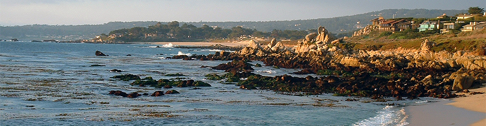
Despite the recent poor weather, the first day of the field trip began bright and early under warm sunny skies. Leaving St Andrews we headed south towards the Forth Estuary to our first stop at Cocklemill Burn. The stratigraphic sections along the Cocklemill Burn have attracted attention since the late 1800s and display records of sedimentary environments extending from the Late Devensian to the present. Here we visited the sections that have formed the basis of studies by Tooley and Smith and more recently by Robinson et al. In these sequences, limnus is overlain by a series of estuarine/marine sands and capped by aeolian sand. Within the marine sands, the Holocene Storegga Slide tsunami deposits are recorded. These sections provided the stimulus for more lively debate on the present-day applicability of the Troels-Smith sediment classification scheme. After a discussion on the reliability of the 14C and OSL chronologies of Cocklemill Burn, we climbed the flight of raised shoreline features to Kincraig Point, where we were presented with spectacular views over the Outer Forth estuary (Figure 2). This coast was one of the first areas of eastern Scotland to undergo deglaciation and the raised shoreline features are interpreted as having formed c. 16 – 17 kyr. The landforms provided an opportunity to discuss the methodology used in the identification and measurement of raised shoreline features, as well as providing a fantastic photo opportunity.
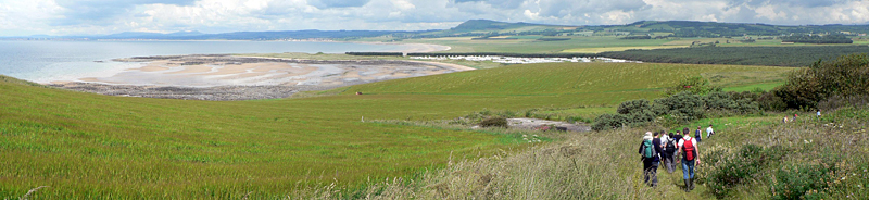
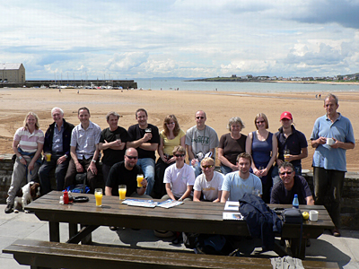
After a sun-drenched lunch break in the picturesque coastal village of Elie (Figure 3), we returned briefly to St Andrews, to our next stop overlooking the famous golf course. Undaunted by a short rain shower, the location provided us with an overview of the foreshore stratigraphy of the St Andrews area, where a cuspate foreland is well-developed, and stimulated discussion on the status of possible interglacial shore platforms. As with many of the sites visited during the two field days, the lack of detailed investigation and a robust chronology limit our understanding of the coastal evolution of the area. Resisting the temptation to core the golf course, we journeyed northwards to our next stop in the valley of the River Eden. The stratigraphic sequences in the Eden valley were last investigated by Chisholm in 1971. However, a lack of radiocarbon dating to constrain the age of these deposits means that the Holocene evolution of the area, and associated RSL changes, are poorly understood. Palaeoenvironmental reconstruction coupled with AMS radiocarbon dating over the next few years by Dawson and Dawson will enable the limited dates available to be placed in their wider context. As with other locations visited over the two days, this stop provided an opportunity to highlight the great potential for new work in this region.
After a stimulating day in the field, the evening was rounded off with a trip to Discovery Point in Dundee, where Captain Scott’s famous polar exploration ship RSS Discovery is berthed and where the conference dinner was served. We were greeted onboard the ship with a champagne reception before being taken on a guided tour of the vessel. Launched for the National Antarctic Expedition of 1901 under the command of Captain Scott, Discovery was one of the last wooden three-masted ships built in Britain, and the first to be constructed specifically for scientific research. Highlights of the tour included viewing the laboratory area and cabins that belonged to the scientists onboard the vessel, including the cabin belonging to Captain Scott himself. The ship provided a spectacular backdrop to the conference dinner, held in the adjoining Discovery museum. Whilst enjoying our haggis, Antony Long recalled happy memories of our recently lost colleagues, Simon Jennings, to whom this meeting was dedicated, and Rhodes Fairbridge, best known for his research on coral reefs and shorelines and the ‘Fairbridge’ sea-level curve.
Following the delicious conference dinner, day two of the field trip focused on former RSL changes in the Tay area and also considered broader issues relevant to RSL changes in Scotland as a whole. In western Scotland, analyses by Shennen et al. for the Arisaig area using isolation basins have greatly aided our understanding of RSL changes in the area. However, these studies are not easily comparable with the classic work of Smith and Cullingford for eastern Scotland, based on geomorphological mapping and lithological studies. In addition, these contrasting methodologies are not easily replicable between east and west. The east lacks the isolation basin sequences used by Shennan, and the west lacks large estuarine sediment sequences comparable to the Forth and the Tay. With these debates in mind, our first stop of the day was at the Gallowflats Claypit. Here, during the Lateglacial, marine and estuarine sedimentation was dominated by the deposition of laminated pink clays and silts, known as the Errol Beds. This location provided us with the opportunity to discuss the relations between the earlier (Lateglacial) and younger (Holocene) raised marine sequences as well as discussing the debate surrounding the existence of the Perth Readvance.
Our second stop of the day, on the southern side of the Tay estuary close to the village of Newburgh, provided us with a panoramic view across the estuary. Here we discussed the relations between the raised marine strata along the southern and northern sides of the Tay. Along the northern embankment, extensive carseland deposits are found, associated with the large volumes of sediment available during the early and middle Holocene. However, along the southern bank of the estuary these deposits are found only in small pockets, such as those viewed close to Newburgh. After another stimulating morning in the field, we made the short journey to Tentsmuir Forest for lunch. Here, another example of widespread dune formation was seen, although the planting of pine plantations in the 1920s by the Forestry Commission made interpretation of the dune suites more difficult. Now, with many of us feeling slightly sunburnt, we headed back to Leuchars rail station where the meeting ended and colleagues bid one another farewell.
On behalf of all delegates who attended this meeting, it remains to pay a heart-felt thanks to the conference organisers Alastair and Sue Dawson for running such a splendid meeting. Thanks also go to Michael Tooley and David Smith for their considerable and much-valued contributions to the two field days. Continuing in the spirit of previous IGCP meetings, the combination of excellent and illuminating science, lively debate and a relaxed and informal atmosphere means that all of us will have fond memories of the St Andrews meeting for many years to come.
Further information on IGCP495 “Quaternary Land-Ocean Interactions: Driving Mechanisms and Coastal Responses” can be obtained from the UK National Correspondent, Dr Roland Gehrels (University of Plymouth, [email protected]).
Dr Katie Szkornik
School of Physical and Geographical Sciences
Earth Sciences and Geography
William Smith Building
Keele University
Staffordshire
ST5 5BG. UK
[email protected]