6th International Conference, USA, 2009 – Conference Report
6th International Conference, USA, 2009 – Conference Report
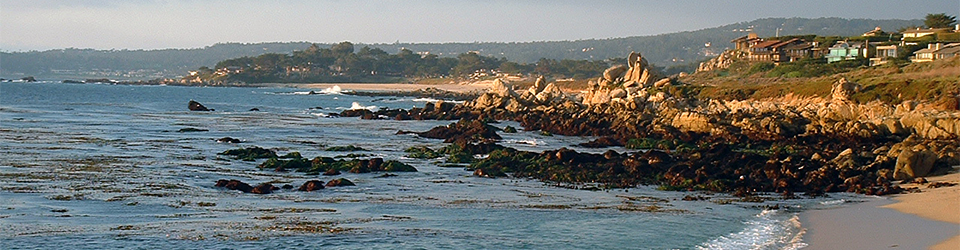
The sixth and final international meeting of the International Geosience Programme (IGCP) Project 495 ‘Quaternary Land-Ocean Interactions: Driving Mechanism and Coastal Responses’ was held in Myrtle Beach, South Carolina 25th-27th October with the accompanying field excursion along the South and North Carolina coast from 28th-31st October. Coastal Carolina University, the United States Geological Survey (USGS) and the South Carolina Sea Grant Consortium kindly hosted the meeting, all expertly coordinated by Dr Paul Gayes (Coastal Carolina University).
After a morning of travel recovery on the sunshine filled beach, the conference opened with an icebreaker and poster session. Many delegates, both experienced and new IGCP project contributors were able to meet and catch up with a complementary beverage or two, characteristic of the friendly atmosphere of these meetings.
The technical session began in earnest the following day with 57 papers presented over two and a half days. Roland Gehrels (University of Plymouth) opened with a fitting tribute to the late Orson van de Plassche. Orson had been a major contributor, organiser and respected member of the IGCP projects over the last 35 years and had worked extensively at many coastal marshes on the eastern coast of the USA. The papers of the first day were collected in tribute to Orson, bringing together many of the locations he had worked at or papers he would have enjoyed on saltmarsh based reconstruction of former sea levels. It was excellent that Orson’s wife, Els, was able to join us for both the technical session and field excursion. Ian Shennan (Durham University) provided personal perspective of the past 35 years of IGCP research and advocated the delights of hypothesis-driven research, followed by the other founding IGCP project member, Cecile Baeteman (Geological Survey of Belgium) with a presentation on Holocene tidal channels of the Belgian Coastal Plain. Ben Horton (University of Pennsylvania) provided an interesting summary of the sea level curves from the Atlantic Coast of the USA identifying the misfit with Peltiers ICE-5G (VM2) model predictions for this area, with an excellent follow on presentation by Törbjorn Törnqvist (Tulane University) focusing on the sea level dataset from the Gulf of Mexico. Antony Long and Sarah Woodroffe (both Durham University) also gave complementary papers on new sea level data from Greenland and the issues of dating recent sediments in the Arctic. After lunch, Alex Wright (VU University) presented work from the eastern USA salt marshes that he had been working on with Orson in the last few years. Much to the amusement of the audience, Craig Sloss (Queensland University of Technology) gave an excellent presentation on Holocene sea level work in New Zealand and then deftly deflected questions citing the absence of his PhD student. Glenn Milne (University of Ottawa) wrapped up the day with the results of the new glacial isostatic model, EUST3, developed by Sarah Bradley (Durham University) that resulted in lively discussion regarding the suitability of the Chinese sea level records for model comparisons. The busy and interesting day was finished with a reception at the Aquarium in Myrtle Beach.
The second technical day continued with the GIA modelling theme, with data-model comparison in the Caribbean region by Matthew Peros (University of Ottawa), followed by modelling of GIA in south central Alaska by Natasha Barlow (Durham University) and Sarah Bradley presenting her latest model results for the British and Irish Ice Sheet. After coffee, the theme turned to rapid coastal events including Davin Wallace’s (Rice University) suggestion that the Gulf of Mexico experienced similar frequency intense hurricane strikes through the late Holocene and Julian Orford’s (Queens University) discussion of the complex processes contributing to gravel dominated coastal-barrier breakdown. In the afternoon, Jennifer Miselis (Stennis Space Centre) reviewed outcomes from a recent workshop on littoral sediment budgets. Rob Thieler (USGS) extended the database of early to mid Holocene coastal evolution of the mid-Altantic US continental margin with new records from the inner shelf, and the technical session was drawn to a close by Walter Barnhardt’s (USGS) discussion of the challenges to resolve model and geological data differences in northeastern Massachusetts. The business meeting allowed Antony Long (Project Leader) to provide a summary of IGCP Project 495, and of course, he could not get away with finishing as project leader without a series of embarrassing photos and video to close!
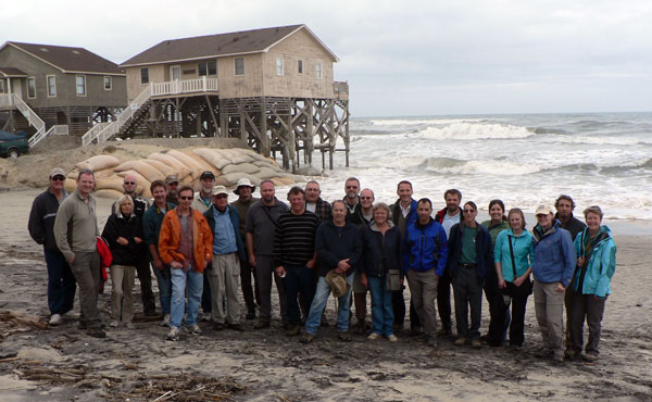
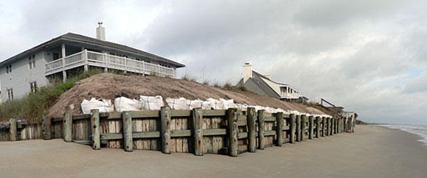
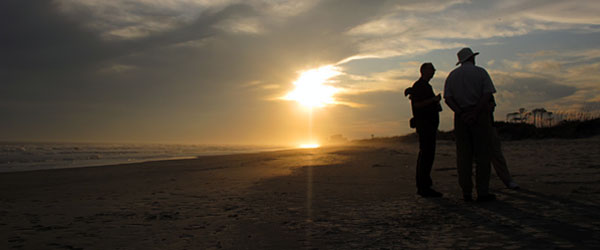
Following a night of major thunderstorms, 23 delegates departed for a 3.5 day field trip along the coast heading north from Long Bay in South Carolina to Duck in North Carolina. Much of Long Bay is highly developed with multimillion-dollar properties, for example the homes at our first stop, Debordieu Beach, that are at risk of coastal inundation. Following lunch at Brookgreen Sculpture Gardens, Wayne Baldwin (USGS) outlined the geologic framework on the coastline and the implications for the present day geomorphology and sediment deposition. However, the main question at Hunting Beach State Park was whether the delegates could spot any alligators! Stop three took us back to Myrtle Beach where John Warner (USGS) and George Voulgaris (University of South Carolina) demonstrated outcomes of some of the sediment transport and wave process observational equipment at Springmaid Pier. In 2004, exceptionally high flounder catches at Apache Pier bought hypoxia events along this stretch of coastline to the attention of Denise Sanger (South Carolina Sea Grant Consortium), and while surrounded by the recreational anglers wielding their fishing rods along the pier, Denise and her team highlighted some of the implications of these periods of dissolved oxygen depletion. The final stop was under the setting sun, with a beer in hand, at the peaceful and largely untouched Waites Island, looking down coast at the development along Grand Strand and considering the Pleistocene evolution of the barrier island.
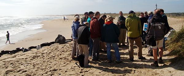
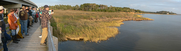
After a morning of travelling on day two, we met with David Mallinson, Stanley Riggs and Stephen Culver (all East Carolina University) on the ferry to the first of the Outer Banks barrier islands: Ocracoke. For the next one and a half days Dave, Stan and Steve provided a very detailed, interesting and humorous insight into the geological processes, Quaternary evolution, sea level change, shoreline management, history, politics and dangers of the Outer Banks; information gathered from of a decade of research under the North Carolina Coastal Geology Cooperative and in Stan’s case, a lifetime of personal experience. We stopped at Isabel Inlet on Hatteras Island, which opened during a storm surge in September 2008, and was rapid filled again by the US government. At this location, and many other sections along the highway that crosses all the main barrier islands, it is possible to be within 150m of the sea on both sides of a road that rides a narrow sliver of sand. Other stops included Cape Hatteras Lighthouse, moved 900m inland as result of the dangers of coastal erosion; Pea Island, where the remains of a never used wooden bridge built in World War II, demonstrated the vulnerability of anthropogenic structures in this dynamic system; and crossed Oregon Inlet on one of the most unsafe bridges in North America (it scored 3 out of 100 in a recent safety test). The stop at Nags Head drove home all the points previously discussed, when we arrived to see septic tanks of “ocean front” houses being buried by dumper truck loads of sand as they had become exposed during the previous storm. These properties, which sit in front of the storm beach, are the second row of buildings to become “ocean front” as the first row of properties have already fallen into the sea. At the final stop, Sand Point platform marsh, Andrew Kemp (University of Pennsylvania) presented the results of his PhD into the late Holocene sea level history of the area, with the assistance of a life-size Tilia diagram! A visit to the US Army Corps of Engineers Field Research Facility at Duck with Director Jesse McNinch on the morning of the fourth day wrapped up a very interesting and varied final conference and field trip of IGCP Project 495.
On behalf of everyone who took part in this conference, I would like to thank Paul Gayes and all the local organisers and contributors who welcomed us all to the Carolina coastline and shared their passion and expertise in coastline dynamics over the course of a meeting that none of us will forget for a long time to come. Last but not least, all project members owe a big thank you to Antony Long for leading IGCP Project 495 to a successful completion. The outputs of the project are numerous (including 5 international meetings, 15 other related conferences, 3 special journal issues, etc) and bear witness to the productivity of the project. We have proposed a follow-up project (IGCP Project 588. “Preparing for Coastal Change”, to be led by Adam Switzer of the University of Singapore) and hope that it will be accepted by IGCP at its next meeting.
Natasha Barlow, Durham University